Gauge of history – An Irishman’s Diary on the West Cork Railway
05 Monday Mar 2018
Posted in Uncategorized

05 Monday Mar 2018
Posted in Uncategorized
28 Wednesday Feb 2018
Posted in Uncategorized
1808. Letting of 200 acres Plantation Measure at Inishbeggeleary, Lands of Bishoprick of Ross, Part of Manor of Aughadown, Skibbereen.
May be Inis Beg almost an island off Skibbereen/Baltimore Road near Creagh Church. The Landlord, Erwin, is not a local.
Have not come across land of bishop of Ross before. The Library of St. Finbarr’s Cathedral has rentals from the 18th century of extensive lands interests at Letterlickey, Durrus, Ballydehob, Schull, Donemark, Bantry, an other ares now in the RCB Library, Dublin.
| Type of deed | Date of current deed | 10 May 1806 | Vol | Page | Memorial | ||||||
| Rent Charge | Date of earlier deed | 573 | 535 | 392897 | |||||||
| No | Role(s) in earlier deed(s) | Role in current deed(s) | Family name | Forename | Place | Occ or title | A | ||||
| A | P1 | ERWIN | Burros | of | Highfield, Barony of W Carbery, Co Cork | Gent | |||||
| B | P2 | SWANTON | William | of | Ballydehob, Co Cork | A | |||||
| C | WD WM | SWANTON | John | of | Ballydehob, Co Cork | Clerk | A | ||||
| D | WD WM | MAHONY | James | of | Bridgetown, Co Cork | Gent | A | ||||
| Abstract | A granted B a rent charge out of the 2 plowlands of Inishbeggaleary, Manor of Aughadown. | ||||||||||
| MS | Date registered | 13 May 1806 | Date abstract added | 20180213 | |||||||
28 Wednesday Feb 2018
Posted in Uncategorized
A list of the church wardens that served in the Church of Ireland parish of Drimoleague (‘Dromaleague’ or ‘Dromdaleague’); 1782 to 1870. Between 1727 and 1818, the parish was united with that of Caheragh and earlier entries contain one church warden from each.
A transcript of the Vestry Book can be found on the Fanlobbus Union genealogy page (thank you, Eunice Jeffers!).
| Page | Year | Name | Address |
| 2 | 1782 | John Taylor | Keelskohonagh, Dromdaleague |
| Thomas Ross | Cooragannif, Caharah | ||
| 7 | 1783 | Thomas Evans | Maulneskehah, Dromdaleague |
| Thomas Baldwin | Mount Musick, Caharah | ||
| 11 | 1784 | William Evans Senr. | Lissangle, Caharagh |
| Luke Taylor | Killskohonagh, Drimoleague | ||
| 23 | 1785 | Nathaniel Skuse | Butler’s Gift, Dromaleague, farmer |
| John Ross | Cooraganniff, Caharah, farmer | ||
| 27 | 1786 | Paul Kingston | Gurteenehir, Dromaleague |
| Richard Goggin | Derreeny, Caharah | ||
| 31 | 1787 | Jordan Lambert | Towneeagh, Dromaleague, farmer |
| Timothy McCarthy | Meanvugh, Caharah | ||
| 37 | 1788 | Edward Nagle | Tonson’s town, Drimoleague, farmer |
| Thomas Wood | Derreeny… |
View original post 783 more words
27 Tuesday Feb 2018
Posted in Uncategorized
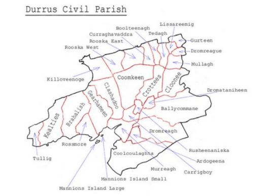
1594-1926, Legal Tenure of Durrus and Surrounding District Townlands, West Cork, Ireland.
Historical definition of Townland as the area that could be ploughed by a Seisreach (A Six-Horse team) in Forty Eight Days. This is from Pádraig Ó Loingsigh history of the parish of Caherdaniel.
Legal Tenure Durrus District Townlands from 1594 to 1926
Including sub denominations there are over 70,000 townlands in Ireland. During the Gaelic and Norman tenure and after the forfeitures and confiscations they continued to be the unit of the Landed Estates. Wealth was held in the form of land.
During the Penal Laws in theory Catholics were locked out of the land market but de facto they probably held 30%. Their attention concentrated on trade. Daniel O’Connell just before he became an M.P. in 1827 stated to a Parliamentary enquiry that in 1827 Catholics held the majority of cash on deposit and shares in the Bank of Ireland, the de facto State Bank.
In this listing various interests are recorded, of interest from a genealogical, social, economic, religious and political viewpoint. From around 1910 most of the tenanted land was vested in the tenants, subject to the payment on an annuity. The British Government financed the purchase from the Landlords who were paid handsomely.
The details are abstracted from old deeds, memorials and other sources, it is often difficult to make out names and places. The exercise could be conducted for any part of Ireland.
Some Townlands:
Ahagouna (Irish: Ath Gamhna, meaning ‘Ford of the calves’). In Clashadoo townland. The ford with stepping stones still extant used before the bridges at Clashadoo built c 1700.
Ardogeena (152 acres) (Irish: Ard na Gaoine, meaning ‘Height of the flint stones’). On the east side is Lisdromaloghera (Irish: Lios Drom Luachra, meaning ‘Fort of the rushy ridge’). Bounded by Boolalaghta.
Ballycomane (1,349 acres) (Irish: Baile an Chumain, meaning ‘town of the little valley’). Part of it is Ballinwillin (Townland of the mill) with a boulder burial, with the remains of a millrace which may have been used by monks at the nearby church of Mouliward, ringfort and standing stone pair. Mass rock in Vincent Hurley’s farm. The oldest family are probably the Hurleys (Vincents), they possibly moved from Ballnacarriga outside Dunmanway and Darby Hurley who held Ballycomane Middle was allegedly evicted by Lord Carbery when a rent payment was missed, the farm was then given to the Vickerys c 1770. The O’Neills are also significant farmers with an old impressive farmyard. On the western end an area known as Cummer. Since the 1950s large parts forested, in the western end of the higher farmed land remains of old native woodland. Two flax ponds at least on O’Neill holding western end, Sam Attridges’ farm abbuting Durrus River. Cromlech at north end. Fort Lís Ballycomane.
Ballydivane (Friendly Cove), name occurs in deeds and Evanson family records.
Boolteenagh (148 acres) (Irish: Buailtinach, meaning ‘summer pasture’). The high land at the south is called Knockboolteenagh (cnoc buailtineach) hill of the little boolies. Site of a possible souterrain, at the north side is a ringfort.
Brahalish (784 acres) (Irish: Breach Lios, meaning ‘spotted fort’) or Braichlis (place of malt or fermented grain). Appears in Patent Rolls 1603. Four forts on the west side is Brahalish Fort and the east Cummer Fort. In 1659 census written Bracklisse. Probably church at Killbrahalish. Burial ground for children, horizontal mill stone with a rindbar near the farmhouse of David Shannon on the eastern side, ringforts. Location discovered by Owen Sullivan 1843, of Brahalish gold fibula (clasp) currently in the British Museum. There are a series of walkways dating from at least the 19th century from the shore to the upper lands where people used to take baskets of seaweed to fertilize their small holdings.
Carrigboy (116 acres) (Irish: Carraig Buidhe, meaning ‘yellow rock’). Location of Durrus village. The high road from here is built over land known as Carrig Cannon. Village demolished and rebuilt by Bandon Estate c 1850. Near the former farmyard of Denis John L O’Sullivan now housing the remains of a souterrain partly demolished during house building between the upper and lower road to Bantry.
Curraghavaddra (195 acres) (Irish: Currach an Mhadra, meaning ‘the bog of the dog’). On the west side is a ringfort.
Clonee (409 acres) (Irish: Cluain Fhia, meaning ‘meadow of the deer’ or ‘Aodh’s meadow’). In the center is Clonee ringfort. Off the road near Jimmy (Bens) Swantons is a disused quarry used in providing stone for tarring the Durrus/Bantry Road last worked in the hot summer of 1940. Flax pond at the Inches on Jimmy Swanton’s farm abutting Durrus River.
Clashadoo (749 acres) (Irish: Claise Dubha, meaning ‘dark hollows’). Burial ground last burial 1930s layout of stones suggest an adult as well as children.. To the north on high boggy ground is Coolnaheorna or Coornaheorna (this appears in the 1740 deed to Francis Bernard as a half ploughland) covering the former farms of Kellys and Sullivans leading to the ‘Cumar’, and beyond to Loch na Fola (lake of the blood). This may have been far more extensive in former times as the stream feeding it may have been diverted; the stream (Moire or in Irish Maighre) on the western end has a deep hole formerly known as Poul Nora Poll Nora (Nora’s hole). Between Rossmore and Mannion’s Island at half tide a rock ‘Carrig Coolnaheorna’ is visible; this marked the spot where people from Upper Clashadoo were entitled to take seaweed to fertilize their smallholdings. On the road to Coomkeen, at the eastern end is a graveyard used for unbaptised infants probably the site of Dun Clashadoo marked on the Ordnance Survey map. The ordnance survey map of 1842 shows ‘Cappanamanna’ on high ground to the west of the old rectory, it appears as ‘ a half ploughland at Cappamonagh’ in the 1740 deed to Francis Bernard and perhaps it may have some old connection with monks. Football field in the 1930s opposite old rectory near bridge. Fort Lís Clashadoo. . The name Brookfield or Durrus Court is derived, I suppose, from the little brook which flows in front of Evanson’s house, and which was formerly called Moire (Maighre) by the old people.
Coolcoulaghta (1148 acres) (Irish: Cul Cabhlachta, meaning ‘remote place of the ruins’ or ‘cul cuallachta’ Nook of the tribe or assemblage. Old name in some deeds Carpolite. In the upper part is an area formerly called Cumha na acrai and the hill on top is Peakeen or Mount Corrin. Location of boulder burial, burial ground at cillín for unbaptised infants. Coolcoulaghta Church contains 1847 famine victims, cairn, coastal promontory fort, fulachta fiadh, ringfort, standing stone, a standing stone pair. Sub-townland ’Galans’ off main road near Blair’s Cove on southern side. Overlooked by Peakín na cCloch (The point of the stones), placename Coo-na-Croi.
Coomkeen (915 acres) (Irish: Cum Caoin, meaning ‘gentle valley’). Mass rock on the lands of Timmy Whelehan deceased known as Tober an tSagairt, on the south side is Screathan na Muice (stoney slope of the pig) this is given as the address of one of the Dukelows in the 19th century, c 1850, marriage register of St.James’s church., to the north is Crock a wadra. On the flat bog before the turn for Clashadoo are clay pits on the right used for road making. The Coomkeen farmers had rights to sea wool between what is now the pier and the sand quay used to fertilize their holdings.
Crottees (490 acres) (Irish: Cruiteanna, meaning ‘humpy ridges’), location of large stone associated with Dukelow family. On the bounds with Clonee an area known as ‘Chapel Brake’ according to Dan Burke, Coomkeen, RIP, used as a church pre 1794 before new road built.
Dromreagh (842 acres) (Irish: Drom Riabhach, meaning ‘striped/grey ridge’). On the north side is Coill Breach (wolf wood). Possible souterrain, standing stone. Dromatiniheen (97 acres) (Irish: Drom a’tSionnaichin, meaning ‘ridge of the little fox’). Ringfort on the south side. Fulach Fia discovered 2016 in works fro new GAA pitch. 1624 Inquisition Car 1.
Dromreague (92 acres) (Irish: Drom Reidh, meaning ‘even ridge’)
Dunbeacon, sub townland Barrakilla
Dunmanus (Irish: Dun Manus, meaning ‘fort of Manus’)
Durrus (Irish: Dubh Ros, meaning ‘dark wooded promontory’)
Gearhameen (646 acres) (Irish: Gaortha min, meaning ‘small wooded glen’). On the east side is Coolnalong Castle seat of the McCarthy Muclaghs later the property of Lord Bandon. On the Clashadoo side is Fahies (na Faithi) containing a disused quarry operated by the Spillane family used to provide stone for the Catholic church. There was a Fullach Fia in a large field opposite Durrus Court removed during agricultural improvements in the 1950s. Former graveyard and flax pond in Sam Attridge’s lands no remains.
Gurteen (127 acres) (Irish: Goirtin, meaning ‘small field’)
Kealties (614 acres) (Irish: Caolta, meaning ‘narrow strip of land/or marshes marshy streams’). On the south side is Ros na Bruighne (headland of strife), written Glinkelty (Gleann Caolta) on 17th century map of Petty. Standing stone and possible ringforts. The high ground was known as Caolagh. Old church pre 1800 remains still visible.
Kiloveenoge (Irish: Cill Ui Mhionoig, meaning ‘Minogue’s church’, or Cill Oighe Mhineog meaning ‘church of the virgin Mineog’). Child burial ground, on the east side is a former Protestant Church built 1860, the west side is the site of an old church and burial grounds. Some distance from where Mike Hegarty’s shop was located is a grave of sailors who were shipwrecked, marked with thorn bushes, possibly from c 1850. 1603 Patent Roll Jae 1.
Lissareemig (78 acres) (Irish: Lios a’Riamaigh, meaning ‘fort of victory’). Ringfort in centre.
Mannions Island, (c 44 acres) used 19th century by Marmions, Skibbereen for horses, Carbery Island 1900 by the Philips family for horses. Salt marshes when horses used it acres of narcissi
Moulivarde (Irish: Meall an Bhaird, meaning ‘the bard’s knoll’), site of old Durrus Church and graveyard.
Mullagh (173 acres) (Irish: Mullagh, meaning ‘summit’). Possible souterrain on the west side is Lissavully Fort (lios a’Mhullaigh) fort of the summit.
Murreagh (199 acres) (Irish: Muirioch, meaning ‘seaside marsh’). Location of disused grain store also used as a refuge for children in 1847. Disused slate quarry south end also standing stone.
Parkana (Irish: Pairceanna, meaning ‘fields’)
Rooska West (298 acres) East (295 acres) (Irish: Riasca, meaning ‘marshes’). Disused lead mines on western side ringforts in West and East. On Ordnance Survey Name Books reference to a burial place for small pox victims then (1840s) disused.
Rossavanna, appears in 18th century deeds. Probably between Rossmore and Gearhameen.
Rossmore (310 acres) (Irish: Ros Mor, meaning ‘large copse or large promontory’). Location of Rossmore Castle in ruins former McCarthy sometimes ascribed to O’Mahony tower house and location of former slate quarry. In the field west of Attridges off the road there is believed to be a famine graveyard as told to Nancy Dukelow by her father Tom. This may be in fact the graveyard marked ‘cillín’ on the ordnance survey map to the east of Attridges in Jimmy Hegarty’s yard which David Shannon of Rossmore says may also have been the site of an old church or a pre workhouse refuge for destitute people. The townland name occurs on Prince Edward Island, Canada to which some Rossmore families emigrated from the 1820s.
Rusheenasiska (84 acres) (Irish: Ruisin an Uisce, meaning ‘little copse of the water’)
Teadagh ( 107 acres) (Irish: Taodach, meaning ‘rugged land’ or Teideach, meaning ‘flat topped hill’) . Associated with O’Sullivan Hurrug family now largely forested.
Tullig (Irish: Tullach, meaning ‘mound’), location of O’Donovan houses at the Cove and Fort Lodge.
26 Monday Feb 2018
Posted in Uncategorized
Western Bandon Estate including part Caheragh 1784-1808
Lease of 1784 from James Bernard, Castlebernard, Bandon to John O’Connor, Skibbereen of lands at (Schull, Ballydehob, Caheragh, Western Bandon Estate). Cahirlekenny, Mauldeny, Rathcool. Bawnicane, Balleenoutragh, Keelbronoge, Dunkelly, Dereenlomane, Lisanaroe, Ballyourane, Letterscanlon. Release 1806 to Francis Earl of Bandon from Cornelius O’Connor, Esq., Newtown, Bantry, Daniel O’Connor, Gent. Skibbereen, George O’Connor, Bantry, Gent. Spellings may not be correct.
22 Thursday Feb 2018
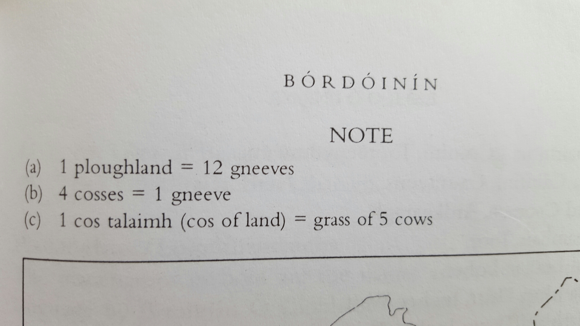
Old Irish Land Measurements Ploughlands and Gneeves frequently appear as land measurements in estate surveys, and deeds, leases, mortgages, marriage settlements up to the early 19th century.
In Gaelic society wealth was often computed by the number of cows a man had i.e. ‘Fear dhá bhó’ (a man of two cows)
Posted by durrushistory | Filed under Uncategorized
22 Thursday Feb 2018
Posted in Uncategorized
1822, Memorial to Build Bridge over River Caha, To Inchigeela, with Drawings, Over 1 mile North East of Dunmanway, West Cork, background of Memorialists.
By 1820 there was a good network of roads and bridges over the centre of West Cork with regular coach services to Cork. However the peripheral peninsulas suffered from a deficit as did connections cross country. There was a concerted effort by local worthies to compel the central authorities at Dublin Castle to remedy this by building roads and bridges. In the main they were susessful with superb road built by Griffith adn Nimmo by th eearly 1830s.
1822, Proposed Bridge DunmanwayInchigeela
17 Saturday Feb 2018
Posted in Uncategorized
16 Friday Feb 2018
Posted in Uncategorized
Julius Reuter was the first to see the opportunity. With his fellow Prussian William Siemens he promoted the South-Western of Ireland Telegraph Company, a sixty mile line from Cork to Crookhaven, a desolate point on the Atlantic coast. This immediately led the British & Irish Magnetic Telegraph Company, the second largest in the country, and which dominated the Irish market, to commence its own line from Cork by way of Skibbereen to an even more desolate and exposed site on Cape Clear, on Clear Island.
The Magnetic company and Reuter raced to open the Cape Clear and Crookhaven lines; Cape Clear opened in November 1863, Crookhaven in the following month.
Eventually there were to be four coastal telegraph stations that picked up canisters for news or public messages from passing steamers: Crookhaven, worked by Reuter and the South-Western company; Cape Clear, worked by the Magnetic Telegraph Company with a cable from Clear Island to Baltimore on the mainland, and another at Roche’s Point, worked jointly by the London & South of Ireland Direct Telegraph Company and the Universal Private Telegraph Company, from Queenstown, the out-port of Cork—all these three connected by dedicated line with either the Magnetic’s or the London & South of Ireland’s offices in Cork city.
There was a short cable to Cape Clear island from the Irish mainland, Crookhaven was entirely an overhead circuit.
At Crookhaven there was a small steamer, the Marseilles, owned by Reuter, with a crew of three. They met the Cunard liners at sea. Without stopping, the liner tossed overside a large canister with messages and telegrams from America. The canisters were painted a vivid yellow topped with a flag, and Reuter’s men gathered them up with a “butterfly net”. It was dangerous work; the boat’s skipper, Michael Driscoll, fell overboard and drowned in March 1865 whilst trying to salve a container of telegrams.
The Magnetic company’s Cape Clear outpost quickly became a meteorological station and then closed in favour of Crookhaven about 1870.
Roche’s Point also maintained the lighthouse for Cork, the station for pilot boats and a meteorological post. Although the telegraph was taken over by the Post Office it seems to have faded away slowly and anyway was little used for news as Cape Clear and Crookhaven were farther out in the Atlantic.
Courtesy:
http://atlantic-cable.com/Article/NewsTelegraphs/index.htm
It was a dark night in early December 1863. At the farthest southwest point of Ireland, Mr Reuter’s small steam-tender sheltered in the lee of the Fastnet Rock. Out of the gloom, with a deafening clunking of paddle-wheels, a vast steamer appeared. As it neared the smaller boat, several canisters, each one lit by a phosphorous flare, were dropped overboard into the sea far below. The steamer continued on its way, and the sound of its engines receded back into the darkness. Meanwhile, on the smaller boat, men grabbed long poles with nets attached and began fishing around for the canisters which still bobbed on the waves. As it swung round to return to the nearby little port of Crookhaven, two clerks below deck unscrewed the tops of the canisters and began sorting the messages inside.
At this date, Julius Reuter’s chain for conveying news between the US and Britain was state of the art:
https://blogs.thomsonreuters.com/answerson/lincoln-gettysburg-address-transatlantic-news/
Use of Shell Lime Mortar in Crookhaven Church Barony of West Carbery built probably before 1500.
13 Tuesday Feb 2018
Posted in Uncategorized
This gallery contains 11 photos.
Originally posted on West Cork History:
https://www.google.ie/maps/@51.734212,-9.13589,14z 1702, Deed from Rev. John Patrickson, Chantor of Cloyne (Dunmanway Patricksons ancestors of Durrus Blairs)…
