Kiloveenogue:
Gortacloona:
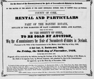
Proposed sale of Bantry Estate 1852, West Cork, at Landed Estates Court with Map of Estates, showing Silver Mines at Gurtycloona and Kelvenogue. It is not certain if the sale proceeded. The silver mines may be lead. The Valuation Office records state that the Kileenovogue mines were working in the 1860s.
The Gortacloona mine may be the same as the one at Aughigheen in the Ordnance Survey Historical map c 1840 of disused lead mine. For soe years in the 1980s the disused school in this townland had an experimental theatre.
There is a 12th century reference to a Silver Mine or Lead Mine in Durrus probably at Gearhameen in one of the English archives.