
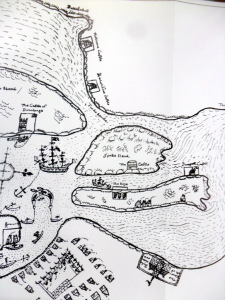
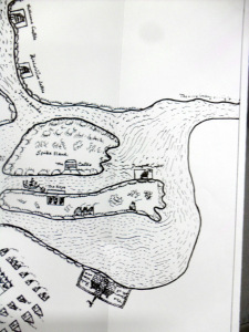
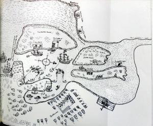
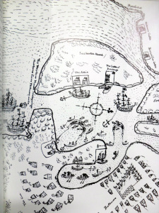
Early Map of Baltimore, West Cork (Between 1605-1640), showing English Settlement, Dunasead Castle, Loo Rocks, Storehouse for Preserved Fish, 12 Fishing Boats, Seine Pilchards, 5 Possible Royal Navy Boats.
Courtesy JCHAS, 1984.
Some time after the Port was raided by Algerian Pirates.
http://en.wikipedia.org/wiki/Sack_of_Baltimore
The Baltimore Fishery was part of a larger fishery including Leamcon, in Schull controlled by Sir William Hull, that of Whiddy Island rented by Davenant from O’Sullivan Bere and that of Cornwall. Hull may have had another fishery in Newfoundland. The fisheries were financed by London merchants.

Pingback: 1692. Colonel Thomas Becher Appointed Governor of Island of Inshirken (Sherlin) near the harbour of Baltimore, West Cork, Salary of 10 Shillings a Day. | West Cork History
Pingback: 1837. Map of West Cork and some Earlier Maps. | West Cork History
Pingback: 1788, Bantry, Some Pilchards Taken. Hopes of Return of Shoals Dashed. 1791 Map Co. Cork River Systems. | West Cork History