
Earl of Bandon Estate Rental Records, Durrus area 1854-1909
https://docs.google.com/spreadsheets/d/1LVgcai4i4QWpyLFvKhEgQAMjtdhjI6VhRrBr2XMWC2U/edit#gid=0
The history of the estate is as follows, this was McCarthy land. They moved their castle in Scart about 1 km north of the Bantry Drimoleague road past Durrus cross with no trace left to a very substantial castle at Gearhameen c 1615. Believing that peaceful time had come like Coppingers Court had no defensive features. Seized by the English post 1641 for ‘Rebellion’ it passed first into the hands of Colonel Reid, then about 1690 was acquired by the Evanson family.
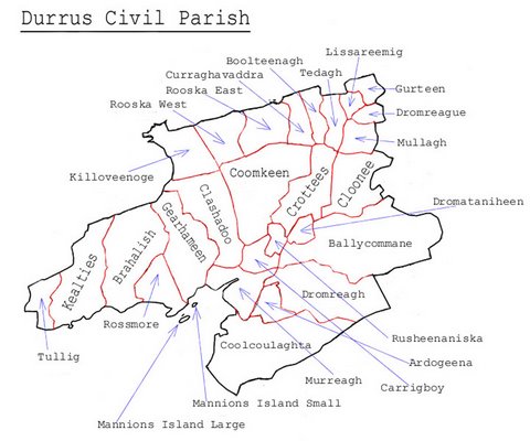
Townlands in the Earl of Bandons Estate.
Briefly, those lands are bounded by the Durrus river and Dunmanus Bay from Crottees to Brahalish on the south side of the Muintervara Peninsula bounded by the high ground dividing the peninsula.
.
Durrus Townlands
Historical definition of Townland as the area that could be ploughed by a Seisreach (A Six-Horse team) in Forty Eight Days. This is from Pádraig Ó Loingsigh history of the parish of Caherdaniel.
Ancient Land Divisions:
Thomas Larcom, the first director of the Ordnance Survey of Ireland, made a study of the ancient land divisions of Ireland and summarised the traditional hierarchy of land divisions thus:[9][12] 10 acres – 1 Gneeve; 2 Gneeves – 1 Sessiagh; 3 Sessiaghs – 1 Tate or Ballyboe; 2 Ballyboes – 1 Ploughland, Seisreagh or Carrow; 4 Ploughlands – 1 Ballybetagh, or Townland; 30 Ballybetaghs – Triocha Céad or Barony.
Ahagouna (Irish: Ath Gamhna, meaning ‘Ford of the calves’). In Clashadoo townland. The ford with stepping stones still extant used before the bridges at Clashadoo built c 1700.
Carrigboy (116 acres) (Irish: Carraig Buidhe, meaning ‘yellow rock’). Location of Durrus village. The high road from here is built over land known as Carrig Cannon. Village demolished and rebuilt by Bandon Estate post 1853. Near the former farmyard of Denis John L O’Sullivan now housing the remains of a souterrain partly demolished during house building between the upper and lower road to Bantry.
Clashadoo (749 acres) (Irish: Claise Dubha, meaning ‘dark hollows’). Burial ground last burial 1930s layout of stones suggest an adult as well as children.. To the north on high boggy ground is Coolnaheorna or Coornaheorna (this appears in the 1740 deed to Francis Bernard as a half ploughland) covering the former farms of Kellys and Sullivans leading to the ‘Cumar’, and beyond to Loch na Fola (lake of the blood). This may have been far more extensive in former times as the stream feeding it may have been diverted; the stream (Moire or in Irish Maighre) on the western end has a deep hole formerly known as Poul Nora Poll Nora (Nora’s hole). Between Rossmore and Mannion’s Island at half tide a rock ‘Carrig Coolnaheorna’ is visible; this marked the spot where people from Upper Clashadoo were entitled to take seaweed to fertilize their smallholdings. On the road to Coomkeen, at the eastern end is a graveyard used for unbaptised infants, small stones, adults large stores, probably the site of Dun Clashadoo marked on the Ordnance Survey map. The ordnance survey map of 1842 shows ‘Cappanamanna’ on high ground to the west of the old rectory, it appears as ‘ a half ploughland at Cappamonagh’ in the 1740 deed to Francis Bernard and perhaps it may have some old connection with monks. Football field in the 1930s opposite the old rectory near the bridge. Fort Lís Clashadoo. The name Brookfield or Durrus Court is derived, I suppose, from the little brook which flows in front of Evanson’s house, and which was formerly called Moire (Maighre) by the old people. On the high northern ground there is 280 acres undivided held in common in 15 shares.
Coomkeen (915 acres) (Irish: Cum Caoin, meaning ‘gentle valley’). Mass rock on the lands of Timmy Whelehan deceased known as Tober an tSagairt, on the south side is Screathan na Muice (stoney slope of the pig) this is given as the address of one of the Dukelows in the 19th century, c 1850, marriage register of St. James’s church., and deed of 1862, to the north is Crock a wadra. On the flat bog before the turn for Clashadoo are clay pits on the right used for road making. The Coomkeen farmers had rights to sea wool between what is now the pier and the sand quay used to fertilize their holdings.
Crottees (490 acres) (Irish: Cruiteanna, meaning ‘humpy ridges’), location of large stone associated with Dukelow family. On the bounds with Clonee an area known as ‘Chapel Brake’ according to Dan Burke, Coomkeen, RIP, used as a church pre 1794 before new road built.
Dromatiniheen (97 acres) (Irish: Drom a’tSionnaichin, meaning ‘ridge of the little fox’). Ringfort on the south side. Fulach Fia discovered 2016 in works fro new GAA pitch. 1624 Inquisition Car 1.Rossmore (310 acres) (Irish: Ros Mor, meaning ‘large copse or large promontory’). Location of Rossmore Castle Rossmore Castle in ruins former McCarthy sometimes ascribed to O’Mahony tower house and location of former slate quarry. May have been a centre of pilchard industry 1730s. In the field west of Attridges off the road there is believed to be a
Click here……
https://docs.google.com/document/d/1eDou0ULSXIdWBEs4_y2TEMVqE7GQkJpv6AAninYhuhU/edit
